
Also serving the communities of De Luz, Rainbow, Camp Pendleton, Pala and Pauma
Also serving the communities of De Luz, Rainbow, Camp Pendleton, Pala and Pauma
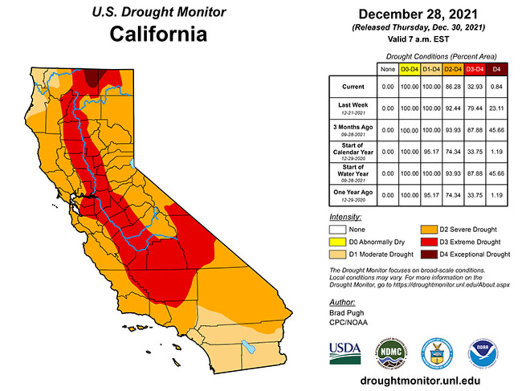
The U.S. Drought Monitor report for Thursday, Dec. 30, shows improving conditions throughout the state. Village News/Courtesy photo
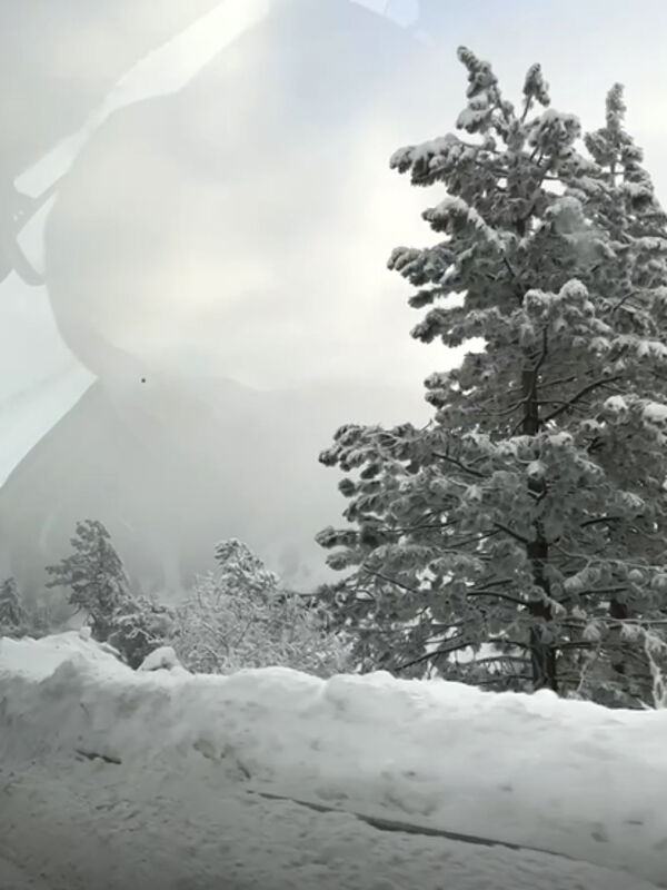
Snow is piled high along California Highway 330 north Wednesday, Dec. 29, after a set of winter storms dumped more than 2.64 inches of snow in the southern California mountains at Snow Valley Mountain Resort, providing some much-needed relief from the drought conditions plaguing the state. Village News/Kirsten Harris photo
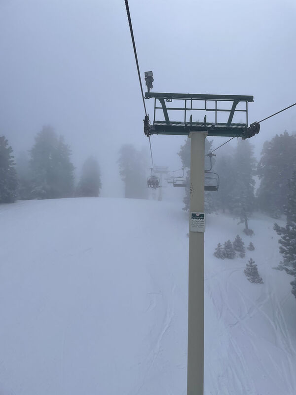
Near white-out conditions at Snow Valley Mountain Resort provide not only a fun day for skiers and snowboarders but also provides some much-needed relief from the drought conditions plaguing the state. Village News/Kirsten Harris photo
Kim Harris
Managing Editor
Despite the threat of La Niña, which usually results in a drier-than-average winter for those in the southwest lasting into February, an abundance of winter storms has brought some much-needed drought relief into the region, water officials said recently.
"We could not have asked for a better December in terms of Sierra snow and rain," Karla Nemeth, director of the California Department of Water Resources, said Thursday, Dec. 30.
The Department of Water Resources conducted the first snow survey of the season at Phillips Station, Thursday. Early winter storms in December provided a strong start to the season and some drought relief, but California still remains in a drought, DWR said in a news release.
The manual survey recorded 78.5 inches of snow depth and a snow water equivalent of 20 inches, which is 202% of average for this location. The snow water equivalent measures the amount of water contained in the snowpack and is a key component of DWR's water supply forecast. Statewide the snowpack is 160% of average.
Officials issue dire warnings
Earlier in 2021, nearly all California counties continued to suffer with extreme or exceptional drought, according to U.S. Drought Monitor data, and water experts said that California wasn't ready for what some were saying would be the worst drought since record-keeping began in 1896.
Much of the state received less than half of average rain and snowfall in 2021 with some areas seeing as little as a quarter of its average precipitation. For most of Northern California, the past two years was the second driest on record.
Water stored in major reservoirs was far below normal as some rivers' runoff dipped below the last drought's levels. Lake Oroville, which stores water delivered as far away as San Diego, dropped to less than one-third of its historic average for this time of year.
"We are in worse shape than we were before the last drought, and we are going to be in even worse shape after this one," Jay Lund, co-director of the Center for Watershed Sciences at University of California at Davis, said in November 2021.
Winter storms bring some relief
But despite the dire warnings and the threat of La Niña, winter storms began moving into the area the week of Christmas, bringing with them an abundance of rain and snow, pushing the snowpack in the Sierra Nevadas from virtually nothing to an excess of 145% and better of the annual average for this time of year.
As of Thursday, Dec. 30, the Southern Sierras' snow water equivalent measured 173% of average, while the Central Sierra and Northern mountains were at 164% and 145% respectively, according to the California Department of Water Resources. Among staggering snowfall totals in the Sierras, the Northstar resort at Lake Tahoe reported 135 inches since Dec. 21.
Temecula was the big winner in rainfall totals for southwest Riverside County as of Thursday, Dec. 30, with 5.02 inches. Menifee saw 2 inches while Murrieta recorded 2.92 inches. Anza and Fallbrook saw 2.14 and 3.14 inches respectively.
Drought Monitor shows improving data
The U.S. Drought Monitor's weekly report, dated Thursday, Dec. 23, showed that much of the state was in extreme to exceptional drought, while the Thursday, Dec. 30, map showed much improvement following the winter storms with Riverside and San Diego counties both moving from severe or extreme drought back down to the moderate drought level.
The Dec. 30 map showed the percentage of the area in exceptional drought improved from 23.11% to .84%. The percentage of the state in extreme drought now sits at 32.93%, an improvement over the 79.44% reported Dec. 23 and the percentage of the state in severe drought improved from 92.44% to 86.26%.
Due to the storms, the state is in better shape than it was one year ago when 33.75% of California was in extreme and 1.19% was in exceptional drought. For severe drought, the state is in a worse position than it was a year ago when California recorded 74.34% of the state in severe drought.
Reservoir levels improve
Water levels in major reservoirs recovered some, getting closer to the historic averages according to data released online by the California Department of Water Resources. Since the rain began to fall, Lake Perris now sits at 82% and Lake Castaic sits at 46% of their total capacity. Reservoirs to the north, while seeing some gains, such as Pine Flat Lake at 27%, San Luis Reservoir at 30%, Lake Oroville at 38%, Lake Shasta at 29% and even Folsom Lake at 60%, still remain low.
While winter storms have brought some relief, it's important to remember that California is a state that sees cyclical drought cycles so water conservation remains important to the health of the state's water resources.
California remains in a drought emergency
In spite of the rainfall, the water year that ended Sept. 30 was the second driest on record. All of California's 58 counties remain under a drought emergency proclamation, and Californians are still being asked to reduce their water use by 15% over 2020 levels to protect water reserves.
"Californians need to be aware that even these big storms may not refill our major reservoirs during the next few months," Nemeth said. "We need more storms and average temperatures this winter and spring, and we can't be sure it's coming. So, it's important that we continue to do our part to keep conserving – we will need that water this summer."
"Californians only need to look to last winter and the state's disappointing snowpack runoff due to high temperatures, dry soil and evaporation as a reminder that changes to our climate mean it will take more than an average year to recover from drought," DWR said.
"California continues to experience evidence of climate change with bigger swings between wet and dry years and even extreme variability within a season. A wet start to the year doesn't mean this year will end up above average once it's all said and done," Sean de Guzman, manager of DWR's Snow Surveys and Water Supply Forecasting Unit, said.
December is the first of the three typically wettest months of California's water year. Significant January and February precipitation would be required to generate enough runoff to make up for the previous two winters that were some of the driest water years on record.
Wet Decembers are not unusual for California, but in the past, storms have also disappeared for the remainder of the season.
In 2013, the first snow survey provided promising results after a wet December, similar to this year. The following January and February, however, were exceptionally dry, and the year ended as the driest on record, contributing to a record-breaking drought.
On average, the Sierra snowpack supplies about 30% of California's water needs, and the snowpack is an important factor in determining how DWR manages the state's water resources. Its natural ability to store water is why the Sierra snowpack is often referred to as California's "frozen reservoir."
As spring sets in, the snowpack begins to melt. Water that is not absorbed into the ground, called "runoff," trickles into mountain streams, which feed rivers and eventually aqueducts and reservoirs, where it can be stored for use throughout the dry season. Climate change is affecting California's snowpack, as more precipitation falls as rain and less as snow. Excessively dry soils and dry, warm spring temperatures are also reducing yearly runoff, which contributes significantly to drought conditions, DWR said.
DWR conducts five media-oriented snow surveys at Phillips Station each winter near the first of each month from January through April and, if necessary, May.
For tips on saving water, visit http://www.saveourwater.com.
Learn more about current drought conditions, the state's response and informational resources available to the public at the state's new drought preparedness website, https://drought.ca.gov.
Kim Harris can be reached by email at [email protected].

Reader Comments(0)