
Also serving the communities of De Luz, Rainbow, Camp Pendleton, Pala and Pauma
Also serving the communities of De Luz, Rainbow, Camp Pendleton, Pala and Pauma
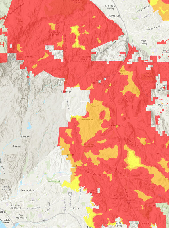
SACRAMENTO – Cal Fire Office of the State Fire Marshal has begun a public comment period for the regulatory adoption process to update the existing map that captures Fire Hazard Severity Zones, which is a comprehensive map that ranks California's State Responsibility Area – or rural, unincorporated areas– based on the likelihood different areas will experience wildfire.
After years of work to develop a sound scientific basis and methodology with a range of experts and stakeholders, updates to this map bring this valuable tool and statutory requirement current in a way that accurately reflects today's reality for wildfire hazard throughout the state. More specifically, this process includes a few details to know below:
· This current revision only updates areas in California's unincorporated, rural areas where wildfires tend to be frequent – called the "SRA" or "State Responsibility Area." This does not include cities or large urban areas.
· This process does not change rules or requirements for homes or properties in these areas related to wildfire prevention, preparedness, and mitigation. The same requirements will remain regardless of whether a particular area is reclassified or not.
· The last Wildfire Hazard Severity Zone map was made in 2007 and required an update. A lot has happened since 2007. Using the best available science with academic researchers and others, this updated map reflects the impacts of a changing climate and includes a variety of other key factors.
· This is the beginning of a nearly two-month public process. These maps are being shared for your comments and questions during the regulatory process. A total of 57 public hearings will be held throughout the state with the goal of hearing from you.
· An online public toolkit and interactive map is available to help answer your questions. Take some time to explore your address, read the FAQs, learn about the process and where to turn. A hotline is also available to help answer your questions directly and to help increase access.
"Ensuring Californians know the wildfire hazard in their area is critical to ensuring we all take the appropriate steps to prepare for wildfires," said Chief Daniel Berlant, Cal Fire Deputy Director of Community Wildfire Preparedness and Mitigation. "The updated map is the product of years of discussions and incorporates the latest science to provide a long-term outlook of an area's wildfire hazard.
Cal Fire's fire scientists and wildfire mitigation experts developed the map using a science-based and field-tested model that assigns a hazard score based on the factors that influence fire likelihood and fire behavior. Many factors are considered, such as fire history, existing and potential fuel (natural vegetation), predicted flame length, blowing embers, terrain, and typical fire weather for an area. These zones fall into the following classifications: moderate, high, and very high.
Working closely with the Department of Insurance and other agencies, Cal Fire is creating a shared approach to further reduce wildfire risk that assists residents and businesses with accessing affordable insurance. The department's first ever report on climate insurance recommended updated wildfire hazard mapping to improve public safety.
Insurance companies and researchers, along with insurance agents and brokers, have been involved throughout this process to ensure cooperation between all sectors to better support Californians. And while insurance companies use similar methodologies to calculate risk as they price their insurance offerings to consumers, insurance risk models also incorporate many factors beyond this process, and many of these factors can change more frequently than those that Cal Fire includes in its hazard mapping.
Cal Fire remains committed to answering all questions from the public and working with the Department of Insurance, the insurance industry, and consumer groups throughout this process.
Overall, the map shows increased fire hazard, reflecting California's increase in wildfire occurrence and severity because of many factors, including a changing climate. The map has been updated to more accurately reflect the zones in California that are susceptible to wildfire, to help provide transparency for planning and preparedness efforts, and to provide communities a forecasting tool so that the public can take steps to prevent and prepare for wildfire.
The hazard mapping process incorporates local climate data and changes in burn probability based on recent trends in fire occurrence. The model was reviewed and validated by members of the science community, as well as with outreach with various stakeholders including insurance, building, fire, and local agencies.
Ways to stay informed and join the conversation
As part of the adoption process of the map, Cal Fire invites public comment on the proposed map between Dec. 16, 2022, and Feb. 3, 2023. The public may submit written comments at the address below or through email at [email protected].
In addition, Cal Fire will host a public comment hearing in all 56 counties that have SRA to receive public comment. The public comment hearing for San Diego County will be on Jan. 9, 2023, 1 p.m. at the San Diego County Operations Center – Chambers, 5520 Overland Avenue, San Diego 92123. The local contact person is Josh Black, 619-609-3413, [email protected].
Written comments may be submitted by U.S. mail to the following address:
Office of the State Fire Marshal
C/O: FHSZ Comments
California Department of Forestry and Fire Protection
P.O. Box 944246
Sacramento, CA 94244-2460
To determine the FHSZ of a property, the public can easily search an address using a new FHSZ Viewer at osfm.fire.ca.gov/FHSZ.
In order to help California residents better understand the FHSZ map and answer questions, Cal Fire has created a public toolkit on its website to include new and easy to follow sections, including maps, frequently asked questions, and an automated "hotline" to contact for specific information. For information about FHSZs, visit osfm.fire.ca.gov/FHSZ. The public can also call an automated hotline at 916-633-7655.
Following the adoption of the SRA FHSZ Map, CAL FIRE – Office of the State Fire Marshal will begin providing local governments updated FHSZ maps for Local Responsibility Areas. Under California Government Code 51178, the State Fire Marshal is required to provide local agencies with the areas within their jurisdiction that meet FHSZ criteria for their local adoption and implementation.
Submitted by Cal Fire Office of the State Fire Marshal.
Reader Comments(0)